8. Projekte Tour: Jüdischer Friedhof
HISTORISCHE INFORMATIONEN ZUM JÜDISCHEN FRIEDHOF
Auf dieser Seite erhalten Sie weiterführende Informationen zum Jüdischen Friedhof vom Denkmal- und Geschichtsverein Bonn-Rechtsrheinisch e.V.
Der Jüdische Friedhof
Die jüdische Gemeinde in Beuel seit dem frühen 19. Jahrhundert:
1854 erhielten die Beueler Juden den Status einer Spezialgemeinde innerhalb der Synagogengemeinde Bonn; 1875 wurde der Synagogenverband mit Bonn aufgelöst.
Gemeindegröße um 1815: 120 (1828), um 1880: 182 (1885), 1932: 130, 2006: –.
Bethaus / Synagoge: Um 1808 wird ein Bethaus genannt. In der ersten Hälfte des 19. Jahrhunderts sowie 1903 wurden auf dem jeweils gleichen Grundstück Synagogen errichtet. 1938 wurde das Gebäude zerstört (vorstehende Angaben alle nach Reuter 2007).
Geschichte des Friedhofs
Die Beueler Juden benutzten zusammen mit den Bonnern den Friedhof in Schwarzrheindorf. Dieser ältere jüdische Friedhof wurde wohl schon im 17. Jahrhundert eingerichtet, der älteste Grabstein ist von 1623. Der Begräbnisplatz wurde 1818 von der jüdischen Gemeinde in Bonn erworben und ist sowohl von dieser als auch von der Gemeinde in Beuel genutzt worden. 1898 wurde die Friedhofsfläche geteilt, die nördliche Parzelle ging zur Synagogengemeinde Villich, der südliche Teil blieb im Besitz der Bonner Gemeinde. Durch die Installation von Flugabwehrgerät 1939 ist der Friedhof erheblich beschädigt worden (uni-heidelberg.de).
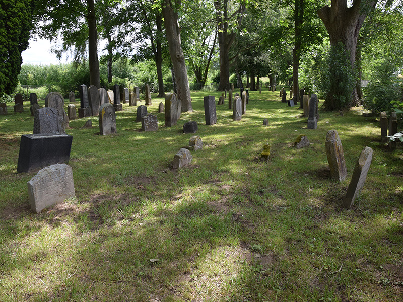
Lage und Zustand
Der Friedhof liegt außerhalb des Ortes in der Gensemerstraße, zwischen der Schwarzrheindorfer Kläranlage und der Friedrich-Ebert-Brücke, unmittelbar dem 2011 neu angelegten Wall (Hochwasserdeich am Rheinufer) mit Rad- und Fußgängerweg. Der baumbestandene, in seinem Pflegezustand verbesserungswürdige Begräbnisplatz ist mit einem einfachen Maschendrahtzaun und zwei Eingangspforten umgeben. Da eine der beiden Pforten offen steht und der Zaun sich in einem sehr schlechten Zustand befindet, ist der Friedhof gut zugänglich. Eine Bank lädt zum Verweilen ein (vergleiche die Bilder in der Mediengalerie, Begehung im Oktober 2011). In der Umgebung findet sich kein Hinweischild auf den Jüdischen Friedhof und auch keinerlei Information an ihm selbst. Gerade an diesem Ort ließe sich ohne größeren Aufwand ein Ort des jüdischen Kulturerbes an die hier zahlreichen Spaziergänger und Radfahrer vermitteln.
Die hiesige Geometrie zeigt den Begräbnisplatz in Umfang und Größe, so wie er heute noch erhalten und erkennbar ist. Die Karten der „Preußischen Neuaufnahme“ von 1891-1912 zeigen den Begräbnisplatz noch auf etwa die doppelte Länge hin nach Südosten hin erstreckt (in etwa der westliche Bereich der heutigen Kläranlage). Seine Größe wird zum Zeitpunkt der Errichtung des Hochwasserdamms mit 226 Meter Länge und einer Breite von 26-32 Meter angegeben (Brocke / Bondy 1998, S. 21); eine Messung anhand der topographischen Karte DGK 5 lässt auf eine Fläche von rund 7.200 QUadratmeter schließen.
Grabsteine und Inschriften
416 Inschriften aus den Jahren 1623 bis 1956 sind in der epigraphischen Datenbank epidat des Essener Steinheim-Instituts dokumentiert.
Die seit 1998 vorliegende umfassende bildlich-textliche Dokumentation des Judenfriedhofs von Brocke und Bondy verzeichnet für das „größte und epigraphisch bedeutendste Ensemble des 17. und 18. Jahrhunderts am Rhein nördlich von Worms“ (ebd., S. 20) insgesamt 453 Grabstätten und 444 Steine von 1623-1956 (größtenteils mit Foto und umfassender epigraphischer Erläuterung).
Baudenkmal / Hinweis
Das Objekt „Jüdischer Friedhof Schwarzrheindorf, Am Hochwasser / Hochwasserdamm“ ist ein eingetragenes Baudenkmal (Denkmalliste Bonn, Nr. A 1854 / LVR-Amt für Denkmalpflege im Rheinland, Nr. 29258) sowie wertgebendes Merkmal des historischen Kulturlandschaftsbereichs Rheinaue bei Schwarzrheindorf, Siegmündung (Kulturlandschaftsbereich Regionalplan Köln 438).
Quelle: Kuladig