ROMAN DENMARK
Information board with detailed presentation of all historical aspects
Information board with detailed presentation of all historical aspects
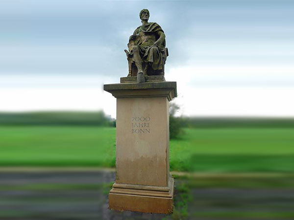
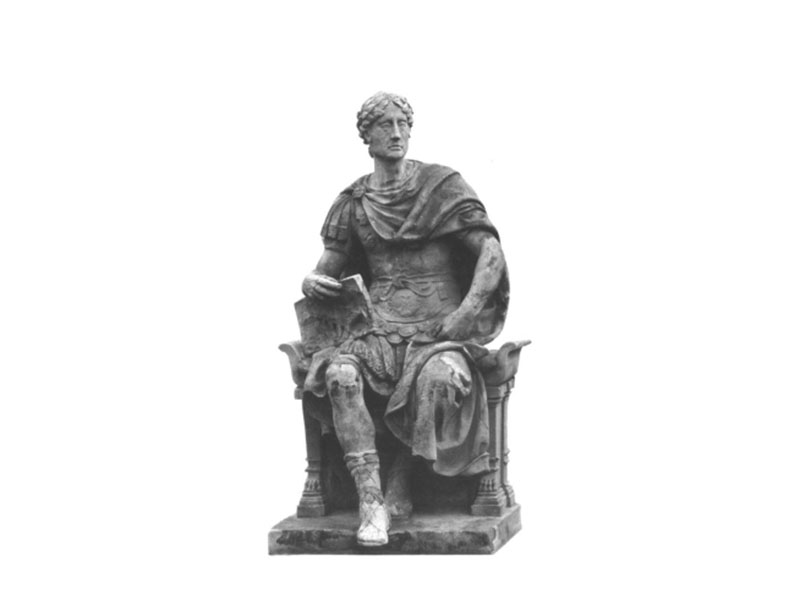
The statue shows Caesar, looking east towards Germania, which is still to be conquered, as a general who is busy with construction plans for a bridge. He is said to have been the first to ever build a solid bridge over the Rhine. This is also written in Latin on the back, carved into the back of the military chair:
C. . IVL. . CAESAR
FLVMINI . PONTEM . PRIMVS
IMPOSVIT
A . A . CHR . N . LV .
G. Iul. Caesar / has built a bridge over the river as the first / in the year before Chr. Geb. 55.
According to today's knowledge, this probably took place in the Neuwied area. However, in 1898, when the first modern Bonn-Beuel bridge was built, it was still believed to have happened here with us. Therefore, this statue of Caesar was initially erected to decorate this bridge (predecessor of the Kennedy Bridge) at the Bonn staircase (now the Opera House). It was created according to a design by the Berlin sculptor Gotthold Riegelmann, who was responsible for the artistic design of the bridge structure as a whole.
After the bridge was blown up on 8 March 1945, the statue was considered lost. Until the Denkmal- und Geschichtsverein Bonn-Rechtsrheinisch e. V. rediscovered it in 1979, arranged for its restoration and gave it a new meaningful location here in 1989 - after an interim stay at the Mehlemschen Haus (next to the Kennedy Bridge). The Bonn stonemasons' guild created the pedestal for it. For a crossing of the Rhine by Caesar close to the mouth of the Sieg, no other place between the Sieg and the Siebengebirge would have been topographically more suitable than the place where we are now. The Roman general Drusus must also have built his Rhine bridge here around 11 BC, if the interpretation of a text by the ancient writer Florus - which is highly disputed among historians - is to be valid:
BONNAM ET GESONIAM CUM PONTIBUS IUNXIT
CLASSIBUSQUE FIRMAVIT.
Bonn and Gensem connected by bridge and secured with fleet station.
The Rhine dike (from 1924/26, raised in 2010/11) runs here on a former island, which is followed by further elevations up to the river channel, which in turn was so interspersed with cliffs and shoals that the terrain offered the best conditions for a crossing exactly here. Therefore, already in prehistoric times, a traffic route leading from the Siegerland through the Siegtal to the Maas found its Rhine ford here. The Romans also maintained a regular ferry service here during their presence of over 400 years, which guaranteed the constant connection of the - exactly opposite - legionary camp with its outpost on the right bank of the Rhine (today the site of the double church) and the military and economic territory of the Beuel hinterland.
After the departure of the Romans, a fixed ferry connection remained right here - on the Arnoldstraße-Augustusring route - for which, for example, a tariff regulation was issued by the Schwarzrheindorf monastery as late as 1314. One of the reasons why the cemetery of Bonn's Jewish community was built not far from here at the end of the 16th century is probably to be found in this ferry station. Later, the ferry service was moved to the south to its present location. For a long time, however, the streets on both sides of the Rhine were called "Fährgasse". The modern shipping traffic on the Rhine, for which the cliffs and shallows of the riverbed represented a dangerous obstacle, was regulated in the 19th century by a signal station ("Wahrschau"), which had its location north of here, at the river bend at the height of today's sewage plant (shortly before the Jewish cemetery). Only after technical blasting, which lasted from 1880 to 1915, was the prehistoric, then Roman Rhine ford smoothed out in favour of today's navigation channel.